 |
|
Thunderstorms. |
|
Our Site Home Live Local Weather Lightning
Data Archives This Year Weather Images Burton on Trent - Floods Gust Cloud & Data Lightning 26/07/2006 Lightning 12/08/2004 Lightning Images Shelf Cloud & Data Sun Pillar Tornado - 23/08/2004 Space Photographs Comet
Machholz Useful Stuff Storm
Chasing Miscellaneous
|
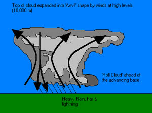
The typical thunderstorm is 15 miles in diameter and lasts an average of 30 minutes. Nearly 1,800 thunderstorms are occurring at any moment around the world.How do they form?You need three basic ingredients to make a thunderstorm. The basic fuel is moisture (water vapour) in the lowest levels of the atmosphere. The air above the lowest levels has to cool off rapidly with height, so that 2-3 miles above the ground, it is very cold. Finally, you need something in the atmosphere to push that moist air from near the ground up to where the air around it is cold. This "something" could be a cold front or the boundary between where the cold air from one thunderstorm meets the air outside of the storm (called an outflow boundary) or anything else that forces the air at the ground together. When that happens the moist air is pushed up. What happens to a blob of moist air as it rises? It cools off and after a while, some of the water vapour turns into liquid drops (that you see as clouds). That warms up the rest of the air in the blob so that it doesn't cool off as fast as it would if the air was dry. When that blob of air gets to the part of the atmosphere where it is very cold, it will be warmer and less dense than the air around it. Since it is less dense, it will start to rise faster without being pushed, just like a balloon filled with helium does. Then more water vapour turns into liquid in the blob and the blob warms up more and rises even faster until all of water vapour is gone and the blob eventually reaches a part of the atmosphere where it isn’t warmer than the environment (typically 5-10 miles).
What type of damage can they cause?Many hazardous weather events are associated with thunderstorms. Fortunately, the area affected by any one of them is fairly small and, most of the time, the damage is fairly light. Lightning is responsible for many fires around the world each year, as well as causing deaths when people are struck. Under the right conditions, rainfall from thunderstorms can cause flash flooding, which can change small streams into raging torrents in a matter of minutes, washing away large debris and some man-made structures. Hail up to the size of golf balls can damage cars and windows, and kills wildlife caught out in the open. Strong (up to more than 120 mph) straight-line winds associated with thunderstorms knock down trees and power lines. How does atmospheric pressure change in and around thunderstorms?Conditions in the atmosphere change a lot over a small distance in the vicinity of thunderstorms. Where the rain is falling, the pressure goes up by a few millibars (about 0.1 inches of mercury). This is because as the rain falls, some of it evaporates, which makes the air cooler and heavier. Another process is going on, however, that makes the picture complicated. As the air goes up in the thunderstorm’s updraft, it creates an area of low pressure under the updraft that acts to pull air in from around the thunderstorm. This low pressure region is also typically a few millibars lower than the environment of the storm. At the top of the storm the pressure is high compared to places far away from the storm and air is blown out. Thunderstorms can occur anywhere in the world and at any time of the day. All thunderstorms produce lightning and thunder. Some have the potential to produce damaging straight-line winds, large hail, heavy rain, flooding, and tornadoes. A thunderstorm is classified as severe when it contains one or more of the following phenomena: Hail 3/4" or greater Winds gusting in excess of 50 knots (57.5 mph) A tornado There are three types of thunderstorms: Single-cell (or air mass), Multi cell cluster, Multi cell (or squall line) and Super cell. Each individual cell lasts about 30-60 minutes and has three stages. Cumulus Stage: Starts with a warm plume of rising air. Mature Stage: The heaviest rains occur. Dissipating Stage: The downdraft takes over entire cloud. As wind shear organizes the convection, new thunderstorms form as a result of parent thunderstorm outflows converging with warm, moist inflow creating new updrafts. Multi cell storms can form in a line known as a squall line, where continuous updrafts form along the leading edge of the outflow, or gust front. Multi cell clusters indicate new updrafts are forming where the low-level convergence is strongest, usually at the right, or right-rear flank of existing cells. Thunderstorms that organize in response to synoptic scale forcing usually need: - warm, moist air at low levels In these conditions, thunderstorm formation is probable. Synoptic scale vertical motions tend to create favourable conditions for thunderstorms, but thunderstorm initiation is usually a result of mesoscale forcing. Increasingly favourable vertical wind profiles may lead to a greater possibility of super cell development rather than multi cell storms. The development of squall lines, or more commonly storm clusters, when thunderstorms do develop is virtually guaranteed in association with synoptic scale forcing. Multicellular storms consist of a series of evolving cells. At low levels, cooler air diverging from the downdraft intersects the inflowing air along a gust front, creating a region of strong low- level convergence favourable for new updrafts. It is the presence of vertical wind shear that results in the "tilting" of the updraft and downdraft. Because of the tilting, the less buoyant downdraft air will not destroy the updraft and hence deprive itself up supersaturated updraft air. In any case, the movement of multi cell storms systems is determined by combining the new cell development with the mean winds. Each individual cell typically moves with the mean winds, while new cells develop where the inflow meets the outflow, hence, in the region of strongest surface, or low-level, convergence. Super cells are the most powerful thunderstorms. By their definition, super cells are always severe. Super cells are responsible for a disproportionate amount of damage and casualties. The most significant difference arises from the presence of a rotating updraft, or mesocyclone. These features insure the longevity of a thunderstorm by allowing the flanking line to enhance the inflow into one main updraft, rather than helping create new updraft centers. The combination of rotation and longevity increase the chances for the development of strong or violent tornadoes. Funnel Clouds, which often get reported in the UK as Tornadoes occur when a storm starts to form with a strong updraft. This acts like water going down a plug-hole and starts to rotate, the rotation acts like a small centrifuge and a small area of low pressure will form within the rotating "vortex" under the base of the cloud. The drop in pressure causes water vapour to condense under the cloud within the vortex forming a visible "funnel" of cloud. This is called a "Funnel Cloud" it is NOT a Tornado. Funnel clouds don't make it to the ground and as a result do no damage How do I know when a thunderstorm is about to occur?When skies darken or thunderstorms are forecast, look AND listen for: Increasing wind. Flashes of lightning. (To estimate the distance in miles between you and the lightning flash, count the seconds between the lightning and the thunder and divide by five.) Sound of thunder. Static on your AM radio.
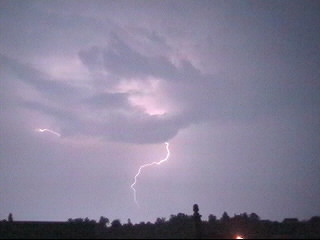
What is Lightning?The action of rising and descending air within a
thunderstorm separates positive and negative charges. Water and
ice particles also affect the distribution of electrical charge.
Lightning results from the buildup and discharge of electrical
energy between positively and negatively charged areas. Most lightning
occurs within the cloud or between the cloud and ground.
What are some myths concerning Lightning?MYTH: If it is not raining, then there is no danger
from lightning. MYTH: The rubber soles of shoes or rubber tires
on a car will protect you from being struck by lightning. MYTH: People struck by lightning carry an electrical
charge and should not be touched. |


The layout, design and content of this web-site are the copyright material of Steven J Warren.
Copyright 2009 All rights reserved.
DESIGN - www.FlyingBunnyStudio.com
NOT FOR PROTECTION OF LIFE OR PROPERTY
The information here is provided for general interest.